
Detroit gets a bad rap for being car-dependent, but I’ve spent enough time navigating this city on buses, bikes, and foot to tell you differently. You can explore Detroit without a car using the DDOT and SMART bus systems, the QLINE streetcar, bike shares, and ride-sharing apps—though having wheels does make life easier. The city sprawls across different neighborhoods, but the public transit system connects most major attractions, and downtown areas are surprisingly walkable once you arrive.
I’ll admit, Detroit isn’t New York or Chicago when it comes to transit. But the system works better than most people expect, especially if you plan your routes ahead and download the right apps. The key is understanding which transportation option fits your destination and being realistic about travel times.
Key Takeaways
- Detroit’s public transit includes DDOT buses, SMART buses, and the QLINE streetcar with affordable fares starting at $2
- Downtown and Midtown areas are walkable with bike-share options, while outer neighborhoods require buses or ride-sharing
- The airport connects to downtown via transit, though most visitors find rental cars give them the most flexibility
Essential Insights for Getting Around Detroit
Detroit’s transportation network works best when you know which tools fit your needs. The city relies heavily on cars, but downtown offers solid alternatives through rail systems, buses, and mobile apps that simplify trip planning.
Navigating Downtown Detroit

Downtown Detroit packs its attractions into a compact area that’s surprisingly walkable. The Detroit People Mover gives you the easiest way to hop between major spots—it’s an elevated train that loops through 13 stations in about 15 minutes. You’ll hit Greektown, Huntington Place, and the GM Renaissance Center without fighting traffic.
The QLine streetcar runs along Woodward Avenue for 3.3 miles, connecting downtown to the New Center district. It stops near Little Caesars Arena and the Detroit Institute of Arts every 8 to 12 minutes. Both the People Mover and QLine run free, which makes them perfect for budget-conscious travelers.
If you’re staying within the 2-3 square mile downtown core, you can walk between most restaurants and venues. But once you venture beyond that zone, you’ll want wheels—whether that’s a rideshare, rental car, or the DDOT bus system.
Key Transit Apps and Passes

The DART app (not DART pass—that’s a different system) connects you to Detroit’s public transit through DDOT and SMART buses. Download it to plan routes, check schedules, and pay your fare digitally. A DDOT ride costs $2 for adults, with 4-hour and 24-hour passes available at $5 for two.
For parking, grab the ParkDetroit app so you can feed meters from your phone without rushing back to your car. MoGo’s bike-share app lets you rent bikes at $0.25 per minute after a $1 unlock fee. The Regional Transit Authority runs the D2A2 bus between Detroit and Ann Arbor—book tickets online for $6 instead of paying $8 at the bus.
SMART Flex operates in suburban areas like Dearborn and Troy with on-demand service through its app. Trips run $2-8 depending on distance.
Accessibility and Safety Considerations

DDOT and SMART buses charge reduced fares of $0.50 for seniors, students, and people with disabilities. The Detroit People Mover and QLine both accommodate wheelchairs at all stations.
Project Lighthouse gives you a safety network throughout downtown. Call 313-471-6490 if you’re lost, separated from your group, or facing vehicle trouble. Look for locations marked with Project Lighthouse banners—18 spots operate 24/7. This augments regular police service (dial 911 for emergencies).
The Detroit Department of Transportation maintains real-time service updates through its app and website. Bus shelters downtown have good lighting, but some suburban stops sit in isolated areas where you’ll want a rideshare instead of waiting after dark.
Public Transit Options in Detroit
Detroit’s public transit network centers on two main bus systems that connect the city and suburbs, with most routes meeting at a central downtown hub where you can transfer between services.
Detroit Department of Transportation (DDOT) Buses

DDOT runs the largest transit system in Michigan, with buses throughout Detroit and into neighboring areas like Highland Park and Hamtramck. You’ll find around ten core routes forming the backbone of the system, plus two routes that run 24/7 if you need to get around late at night or early morning.
The standard fare is $2 per ride. But honestly, if you’re planning multiple trips in a day, you’ll save money with a Dart pass—$5 gets you 24 hours of unlimited rides on both DDOT and the QLine. Weekly passes run $22, and monthly passes cost $70.
You can buy passes through the DDOT mobile app, which beats digging for exact change. The app also shows schedules and real-time tracking for most routes. Major routes like Woodward (Route 4) and Grand River (Route 3) run every 10-15 minutes during peak hours, while smaller routes might only come every 30-60 minutes.
SMART Bus Services and FAST Routes
SMART buses cover the suburban areas aroun
Rail and Streetcar Systems
Detroit offers two complementary rail options that cover downtown and the Woodward corridor. The People Mover circles the downtown core on an elevated track, while the QLINE runs north-south along Woodward Avenue connecting neighborhoods from downtown to New Center.
Detroit People Mover Overview

The Detroit People Mover is your best friend for moving quickly around downtown. This elevated, automated train runs in a 2.94-mile loop with 13 stations, hitting all the major spots you’d actually want to visit.
The best part? It’s completely free through 2026, thanks to a sponsorship deal. You just walk up to the platform and board when the train arrives every 5-7 minutes. No tickets, no fare gates, no hassle.
The system runs clockwise only, so you’ll need to think ahead about which station to exit at. A full loop takes about 13-15 minutes, which means if you miss your stop, it’s not a huge deal—just ride it around again.
Hours vary by day. Weekdays start at 6:30 AM and run until midnight. Weekends start later at 10 AM, with Saturday service until midnight and Sunday ending at 10 PM. Key stations include Grand Circus Park (near Little Caesars Arena and the theater district), Greektown (attached to the casino), and Renaissance Center (right on the riverfront). Times Square station connects directly to the Rosa Parks Transit Center, where you’ll find most bus routes.
QLINE Detroit and Woodward Avenue
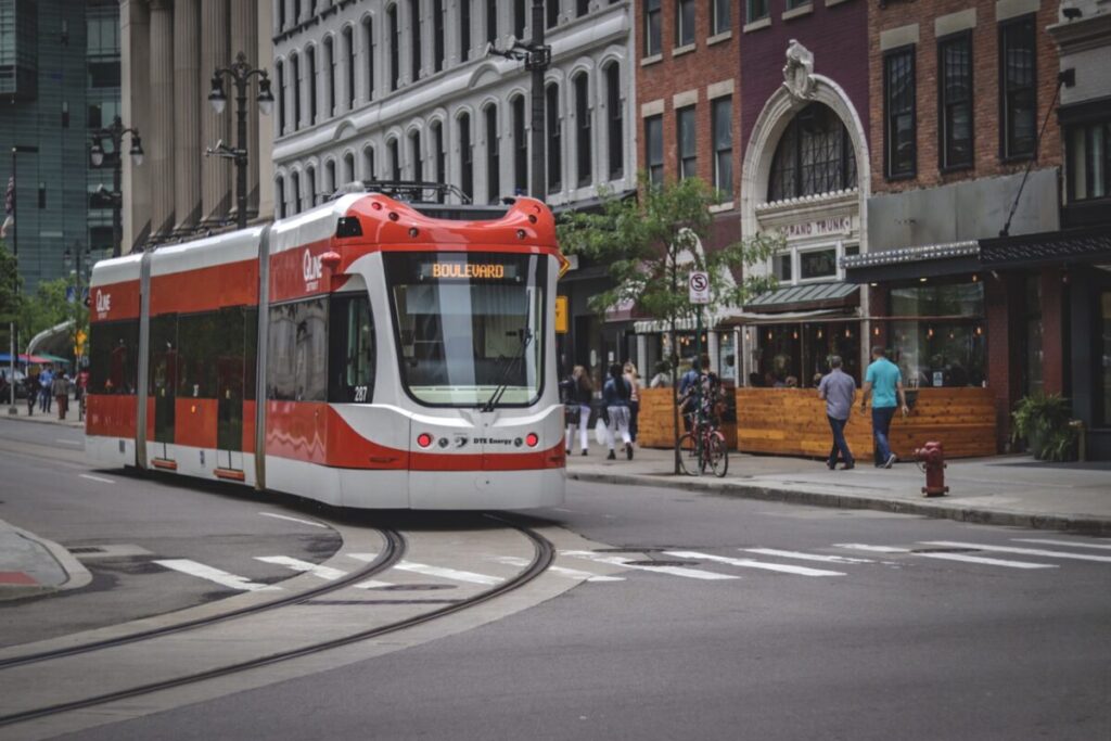
The QLINE streetcar runs along Woodward Avenue for 3.3 miles, connecting downtown to Midtown and the New Center area. This route is perfect when you’re heading to museums, Wayne State University, or dining spots outside the downtown loop.
Unlike the People Mover, the QLINE travels at street level and shares the road with cars. Trains arrive every 15 minutes or so during regular hours. You can transfer between the QLINE and People Mover at Grand Circus Park and Financial District stations.
The streetcar stops at 20 stations along Woodward, giving you access to destinations like the Detroit Institute of Arts, Museum of Contemporary Art Detroit, and the Detroit Historical Museum. Campus Martius, Fox Theatre, and the old GM headquarters building are all along this corridor.
Fares are modest and you can pay via mobile app or at station kiosks. The QLINE accepts the regional DART pass, which also works on DDOT buses, SMART buses, and the People Mover.
Using Transit Apps for Real-Time Schedules
Your phone is honestly more reliable than posted schedules, especially for the QLINE. Download the Transit app or Detroit’s official transit app to see exactly when the next train or streetcar is arriving.
Both the People Mover and QLINE show up in these apps with real-time tracking. You’ll see vehicle locations on a map and get countdown timers for arrivals at your station. This saves you from standing around guessing when service is actually running.
The apps also show service alerts and detours, which happen more often with the QLINE since it runs at street level and gets affected by traffic, events, and construction. Some apps let you plan trips that combine the People Mover, QLINE, and bus routes into a single journey with transfer points clearly marked.
Driving, Parking, and Car Alternatives
Detroit remains a car-centric city where most residents drive, though you’ll find several practical alternatives if you’re arriving by bus or prefer not to rent a vehicle.
Driving in Detroit and Road Navigation

Most people in Detroit drive because the city was built around the automobile industry. The road layout follows a grid system that’s fairly easy to understand once you get the hang of it.
You’ll notice that rush hour traffic gets heavy, especially on major routes like I-75 and I-94. The morning rush typically runs from 7-9 AM, while evening congestion hits between 4-6 PM.
One thing to watch out for: road conditions can be rough. Winter’s freeze-thaw cycle creates potholes that the city constantly works to repair. You might find yourself dodging a few during your visit.
Car insurance rates in Detroit are among the highest in the country, which is worth considering if you’re thinking about renting. The city’s grid makes navigation straightforward, with major arteries like Woodward Avenue running north-south through downtown, Midtown, and beyond.
Parking Solutions and Apps

Finding parking downtown is actually easier than you might expect. Street parking is available throughout the area, and rates are reasonable compared to other major cities.
The ParkDetroit app is your best friend for street parking. You can pay through the app, extend your time remotely, and avoid running back to feed a meter. It’s honestly one of the more user-friendly parking apps I’ve encountered.
For garage and lot parking, ParkWhiz lets you reserve spots in advance at discounted rates. This comes in handy when there’s a Tigers game or event that might fill up nearby lots.
Downtown parking typically costs $5-15 per day in lots, while street parking runs around $2 per hour. Many restaurants and businesses offer validation, so always ask before you pay.
Taxis and Ridesharing Services
Uber and Lyft operate throughout Detroit and are your most reliable options for getting around without your own vehicle. Wait times are usually 5-10 minutes in downtown and Midtown areas.
Traditional taxis exist but they’re less common than rideshares. You won’t easily hail one on the street like in New York. If you prefer taxis, you’ll need to call ahead or find them at designated stands near hotels and the airport.
Rideshare costs are reasonable – expect to pay $10-20 for trips within the downtown and Midtown corridor. Longer trips to outer neighborhoods or suburbs will run higher, sometimes $30-40 depending on distance.
Cycling, Scooters, and Pedestrian Routes
Detroit offers several ways to explore the city without a car, from bike shares and dedicated trails to electric scooters and waterfront paths. You’ll find growing infrastructure that makes pedaling or walking through neighborhoods more accessible than you might expect.
MoGo Bike Share and Wheelhouse Detroit

MoGo is Detroit’s bike share system that lets you grab a bike from one station and drop it at another. It’s handy if you’re hanging out downtown or in Midtown and want to skip driving for a few miles.
There are over 70 stations scattered around Detroit. You can pay per ride or grab a day pass; most passes give you the first 30 minutes free, but watch out for extra fees if you go over that time. Plan your trips so you don’t get surprised.
Wheelhouse Detroit runs MoGo and rents bikes for longer stretches, too. You can rent regular bikes or try their electric-assist bikes, which honestly make Detroit’s occasional hills a lot less of a slog. If you’re not used to biking in a city or want to cover more ground, those e-bikes are a game-changer.
Bike Lanes, Trails, and Dequindre Cut
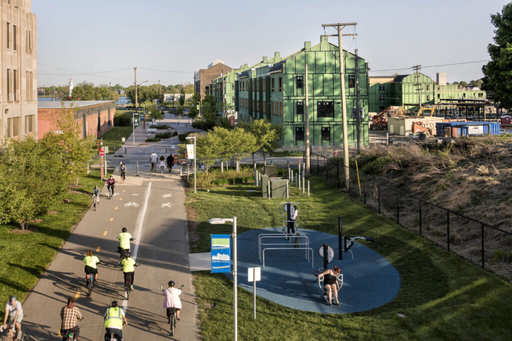
Detroit’s added more bike lanes lately, especially downtown and in neighborhoods like Midtown and Corktown. The city posts bike maps online that show where protected lanes and bike routes are, so check those before you head out.
The Dequindre Cut is one of Detroit’s best biking and walking paths. It’s a paved greenway running below street level from Eastern Market down to the riverfront, and it’s loaded with street art.
This trail hooks up with others, too. Once you reach the river, you can cruise along the riverfront path in either direction. The Iron Belle Trail also cuts through Detroit, so if you’re feeling ambitious, it’s there for you.
Scooter Rentals and Regulations

Electric scooters from Bird, Lime, and Spin are everywhere downtown and in busy spots. Just download the app, scan the QR code, and go.
There are rules, though. Ride in bike lanes when you can, and don’t go over 15 mph. Stay off sidewalks in business districts—stick to the street or marked paths.
Don’t just leave scooters wherever you stop. Park them upright, away from doorways and pedestrian traffic. The apps will show you where it’s okay to park.
Walking the Detroit Riverwalk

The Detroit Riverwalk runs for about 3.5 miles along the river. You can walk from the old Joe Louis Arena site past Hart Plaza, through Rivard Plaza, and down to Gabriel Richard Park. It’s honestly one of the nicest walks in the city.
The path’s wide, well-kept, and gives you a great view of Canada across the water. You’ll pass restaurants, parks, art, and plenty of benches if you need a break.
If you’re coming in by bus, plenty of routes drop you near Riverwalk access points. From there, you can walk to spots like the Renaissance Center or Eastern Market without much hassle.
Getting To and From Detroit Metro Airport
Detroit Metropolitan Wayne County Airport is about 20 miles southwest of downtown. Getting between the two doesn’t have to cost a fortune. You’ve got everything from a $2 bus ride to rental cars and rideshares, depending on your budget and patience.
Detroit Metropolitan Wayne County Airport (DTW)

DTW has two main terminals: McNamara (Delta’s big hub) and Evans (the other airlines). A shuttle runs between them nonstop, so switching terminals is easy.
Both terminals have Ground Transportation Centers where you can catch taxis, rideshares, rental cars, or buses. McNamara Terminal even has an ExpressTram inside Concourse A—super handy if your gate’s at the other end.
Honestly, once you figure out the layout, the airport’s pretty easy to get around. Moving walkways help you cover ground, and the signs are clear enough that you shouldn’t get lost hunting for your ride.
Detroit Air Express Shuttle Details
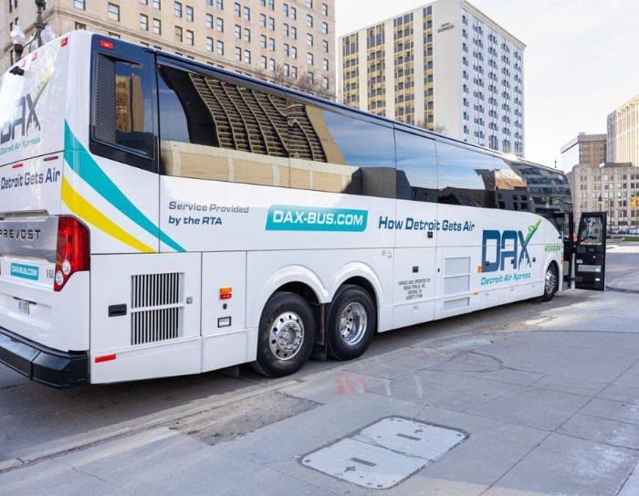
Detroit Air Express runs a shared-ride shuttle between DTW and spots around metro Detroit. Book ahead online or by phone, and they’ll set your pickup time based on your flight.
Shuttles make several stops, so your travel time depends on your destination and who else is on board. If you’re with a group or have a lot of luggage, splitting the cost makes this a solid alternative to a taxi.
Most shuttles hit major hotels and some residential areas. Don’t forget to book your return at least 24 hours before your flight—drivers really appreciate it when everyone’s on time.
Airport Transit Connections
The SMART bus system is the cheapest way to get downtown from the airport. Route 125 goes between DTW and downtown for just $2. Seniors 65+ and kids 6-18 pay $1, and children under 5 ride free.
But heads up—the bus isn’t quick. You’ll spend more time on the road because of all the stops. If you’re in a rush or flying in late, this probably isn’t your best option.
Transportation Options from DTW:
| Method | Approximate Cost | Travel Time |
|---|---|---|
| SMART Bus | $2 | 60-90 minutes |
| Rideshare | $35-50 | 30-40 minutes |
| Taxi | $45-60 | 30-40 minutes |
| Rental Car | Varies | 25-35 minutes |
Look for the rideshare pickup zones at both terminals’ Ground Transportation Centers. During busy times, you might have to wait a bit while drivers deal with airport traffic.
Exploring Detroit’s Top Attractions Without a Car
Most of Detroit’s big attractions sit along transit-friendly routes, so you can hit places like the Detroit Institute of Arts, Comerica Park, and the Fisher Building using public transit and a bit of walking.
Accessing Downtown Landmarks

Downtown Detroit puts most main attractions within reach if you’re using buses or streetcars. The QLine streetcar runs up and down Woodward Avenue and drops you right at spots like Comerica Park during baseball season. No need to stress about parking.
The Guardian Building is in the financial district, and you can walk there from most downtown hotels or QLine stops. It’s a cool art deco building—plan about 30 minutes to check it out.
The riverfront is great if you want things to do in Detroit without a car. Walk the Detroit RiverWalk and catch nearby bus routes. The People Mover train loops around downtown, though its hours are limited and it mainly serves the business district.
Visiting Cultural Venues via Transit

The Detroit Institute of Arts is right on Woodward Avenue, so it’s easy to reach on the QLine. You should budget at least 2-3 hours there; the collection’s huge. Midtown, where the museum sits, has become a lot more walkable recently.
The Fisher Building is another QLine stop away in New Center. It’s an architectural stunner with shops, restaurants, and the Fisher Theatre. You can pair it with a Motown Museum visit, though that’s about a 15-minute walk or a short bus ride.
The Henry Ford Museum is in Dearborn, which isn’t so simple without a car. You’ll need the SMART bus, using routes that link Detroit to the suburbs. Expect about an hour each way, and check weekend schedules since buses run less often then.
Connecting to Suburbs and Canada

Going beyond Detroit’s core is tricky on public transit. SMART buses reach the suburbs, but routes are limited and weekend schedules can be sparse. If you’re trying to see attractions spread out across metro Detroit, you might want to use rideshares now and then.
The Detroit-Windsor Tunnel offers a unique international trip you can actually do on foot or via the Tunnel Bus. Walking is possible, but most folks just hop on the bus between the cities. Bring your passport, obviously.
You can get to places like Royal Oak or Birmingham by bus, but it takes patience and planning. Check routes the night before and allow extra time, especially if you’ve got tickets or reservations.
Frequently Asked Questions
Detroit’s public transportation can seem confusing at first, but most visitors end up asking the same things about getting around safely and cheaply.
What is the most efficient public transport option in Detroit?
The DDOT bus system covers 48 routes across Detroit and gives you the best shot at reaching different neighborhoods. For quick trips along Woodward Avenue, the QLINE streetcar is your fastest bet since it runs on its own track and skips traffic jams.
The People Mover is handy if you’re staying downtown and need to hop between tourist spots, hotels, and entertainment areas. It’s an elevated train looping around 13 stations in the city center.
But honestly, if you’re trying to visit several neighborhoods in a day, you’ll probably have to mix and match different transit options. DDOT buses are reliable, but they’re not fast compared to driving.
Are ride-sharing services like Uber and Lyft widely available in Detroit?
Yep, both Uber and Lyft work throughout Detroit and the suburbs. You’ll get the fastest pickups in downtown, Midtown, and near the airport.
Response times can be slower in some residential neighborhoods compared to places like Chicago or New York, but you usually won’t wait more than 10-15 minutes during the day.
The apps are super useful for late-night trips when buses have stopped or are running less often. Just know surge pricing can pop up during big events or bad weather.
What is the best way to navigate Detroit after dark for safety and convenience
Stick with ride-sharing apps or taxis after 10 PM if you don’t know the city well. DDOT does have some 24-hour routes, but buses come less often at night and you might wait 30-45 minutes.
The QLINE runs until midnight on weekdays and 2 AM on weekends, so it’s a good option if you’re out late along Woodward Avenue. The streetcar stays busy on weekends, and it’s always safer with a crowd.
Downtown and Midtown are generally safe at night, especially near the entertainment districts. Still, like any big city, stay aware of your surroundings and avoid wandering into unfamiliar neighborhoods alone after dark.
Where can I find a map of the Detroit light rail system for planning my trip?
Detroit’s QLINE streetcar is the city’s only light rail, and you’ll find route maps right on the QLINE website or in their mobile app. The line itself is pretty simple—just one route stretching 6.6 miles along Woodward Avenue.
If you’re more of a paper-map person, you can pick one up at any of the 12 QLINE stations or swing by the Rosa Parks Transit Center downtown. Each station has signs that show which way the next streetcar’s headed, so you’re not left guessing.
The Detroit People Mover has maps on its official website and at all 13 stations around the elevated loop.


